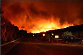
LA Times: Ventura wildfire rages over 45,500 acres, destroys more than 150 structures, triggers evacuation of 27,000
The Thomas Fire has burned an area larger than Washington D.C and continues to threatening Ventura County. (Ryan Cullom / Ventura County Fire Department photo)
Ventura County is being ravaged by the now 45,500 acre creek fire. The fire is larger than all of Washington DC and continues to burn to the west and to the south. For the full article by the LA Times click here.
Here is a full list of mandatory evacuation neighborhoods from The Mercury News:
- Santa Paula: east of Dickenson Road, north of Monte Vista Drive along Highway 150 and south of Thomas Aquinas College to the area of Say Road.
- Santa Paula: west of Dickenson Road to Atmore Road, north of Foothill Road and west to Wheeler Canyon Road.
- Upper Ojai: north of Highway 150 from Koenigstein Road west to the Dennison Grade, north to Reeves Road, east to McAndrew Road and north to Grand Avenue.
- Santa Paula and Ventura: north of Foothill Road west to Wheeler Canyon Road, north to Canada Larga Road and east to Barlow Canyon Road.
- Ventura: south of Highway 33, east of Main St, north of Foothill Road and Hall Canyon Road and west of Canada Larga Road.
- Ventura: east of North Ashwood Avenue along Loma Vista Road to North Victoria Avenue south of Foothill,
- Ojai Valley Inn area: east of hwy 33 west of Creek Road south of Ojai Valley Inn south of Hwy 150.
- Casitas area: north of Canada Larga along Hwy 33 to south of Casitas Vista and north along Casitas Vista Road to Lake Casitas.


Comments are closed.